 www.geodatenkatalog.de (S1F)
Keyword
Deutschland und angrenzende Gebiete
4 record(s)
Provided by
Type of resources
Available actions
Topics
Keywords
Contact for the resource
Service types
-
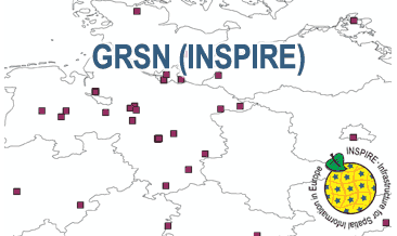
The WMS GRSN (INSPIRE) represents the seismological stations of the German Regional Seismic Network (GRSN) equipped with 3-component broadband seismometer and digital data aquisition system. The recorded data are directly transmitted to the data center at BGR in Hannover and made available to the public near realtime. According to the Data Specification on Geology (D2.8.II.4_v3.0, subtopic Geophysics) the information with respect to the seismological stations is INSPIRE-compliant. The WMS GRSN (INSPIRE) contains a layer of the seismological stations (GE.seismologicalStation) displayed correspondingly to the INSPIRE portrayal rules. Via the getFeatureInfo request the user obtains the content of the INSPIRE attributes platformType, relatedNetwork, stationType und stationRank.
-
The German Regional Seismic Network (GRSN) consists of seismological stations equipped with 3-component broadband seismometer and digital data aquisition system. The recorded data are directly transmitted to the data center at BGR Hannover and made available to the public near realtime. The GML file together with a Readme.txt file are provided in ZIP format (GRSN-INSPIRE.zip). The Readme.text file (German/English) contains detailed information on the GML file content. Data transformation was proceeded by using the INSPIRE Solution Pack for FME according to the INSPIRE requirements.
-
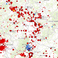
This Web Map Service (WMS) is based on a database providing information on the seismicity in Germany an adjacent areas. It contains locations of seismic events since 800; whereat their epicentre determinations are based on historical sources as well as on measurements of seismometer stations since the start of instrumental seismological recording in the 20th century. Today, digital data acquisition at seismometer stations of the German regional seismic network (GRSN), the seismic GERES array, and the Gräfenberg array (GRF),enables along with near real time data transmission of recorded seismometer data to the seismological central observatory at BGR, the immediate detection and analysis of seismic events, and their provision to the WMS. All events with a local magnitude ML 2.0 and higher are shown. The epicentre determination is initially carried out by an automatic processing procedure. Such a procedure might result - occasionally - inerroneous epicentre estimates and overestimated magnitudes. Therefore results obtained by the automatic procedure routinely post-processed by a manual and inter-active analysis on the following labour day.
-
This Web Map Service (WMS) is based on a database providing information on the seismicity in Germany an adjacent areas. It contains locations of seismic events since 800; whereat their epicentre determinations are based on historical sources as well as on measurements of seismometer stations since the start of instrumental seismological recording in the 20th century. Today, digital data acquisition at seismometer stations of the German regional seismic network (GRSN), the seismic GERES array, and the Gräfenberg array (GRF),enables along with near real time data transmission of recorded seismometer data to the seismological central observatory at BGR, the immediate detection and analysis of seismic events, and their provision to the WMS. All events with a local magnitude ML 2.0 and higher are shown. The epicentre determination is initially carried out by an automatic processing procedure. Such a procedure might result - occasionally - inerroneous epicentre estimates and overestimated magnitudes. Therefore results obtained by the automatic procedure routinely post-processed by a manual and inter-active analysis on the following labour day.